Rural Education Development
Learnthings Africa
Rural South Africa
10 January - 3 February 2010
Background
For nearly a month I traveled more than 7000 km through the Eastern Cape of South Africa (including the area previously known as the Transkei) to install Learnthings and Microsoft software content at poor rural schools on behalf of Learnthings Africa.
 |
| Small shop - near Bizana (Transkei) |
About Transkei
The Transkei (meaning the area beyond [the river] Kei), officially the Republic of Transkei, was a Bantustan—an area set aside for members of a specific ethnicity—and nominal parliamentary democracy in the south-eastern region of South Africa. Its capital was Umtata, which was renamed Mthatha in 2004.
Transkei represented a significant precedent and historic turning point in South Africa's policy of apartheid and "separate development"; it was the first of four territories to be declared independent of South Africa.
Throughout its existence, it remained an internationally unrecognized, diplomatically isolated, politically unstable de facto one-party state, which at one point broke relations with South Africa, the only country that acknowledged it as a legal entity.
In 1994, it was reintegrated into its larger neighbor and became part of the Eastern Cape Province.
 |
| Schoolkids - Jansenville, Eastern Cape |
About the Eastern Cape
The Eastern Cape is a province of South Africa. Its capital is Bhisho, but its two largest cities are Port Elizabeth and East London.
It was formed in 1994 out of the Xhosa homelands of Transkei and Ciskei, together with the eastern portion of the Cape Province.
Landing place and home of the 1820 settlers, the central and eastern part of the province is the traditional home of the Xhosa people.
This region is the birthplace of many prominent South African politicians, such as Nelson Mandela, Oliver Tambo, Walter Sisulu, Govan Mbeki, Raymond Mhlaba, Chris Hani, Thabo Mbeki, Steve Biko, Bantu Holomisa and Charles Coghlan (Wikipedia).
|
|
Graaff Reinet - Eastern Cape
|
Photo highlights
Bizana
 |
| Near Bizana, Transkei |
 |
| Near Bizana, Transkei |
About Bizana
Bizana is a rural village in the Trans-Kei River region of Eastern Cape Province, and the birthplace of Oliver Tambo and Winnie Madikizela-Mandela (SA History online).
 |
| Bizana, Transkei |
 |
| Kids playing on the street near my Guesthouse - Bizana, Transkei |
 |
| Nyaka location, near Bizana, Transkei |
 |
| Nyaka location, near Bizana, Transkei |
 |
| Mpondombeni school, Nyaka location, near Bizana, Transkei |
 |
| Lukholo location, near Bizana, Transkei |
 |
| Lukholo location, near Bizana, Transkei |
 |
| Traditional huts near Bizana, Transkei |
 |
| The scenery on the road between Bizana and Lusikisiki |
 |
| The scenery on the road between Bizana and Lusikisiki |
 |
| Shop on the road between Bizana and Lusikisiki |
About Lusikisiki
Lusikisiki is a town in Ingquza Hill Local Municipality in the Eastern Cape province of South Africa. This village is 45 km north of Port St Johns in East Pondoland. It developed from a military camp established in 1894, was surveyed in 1902 and administered by a village management board since 1932 (Wikipedia).
Lusikisiki is wild. The countryside is rugged, remote and untamed, and time has virtually stood still in a part of the world known as ‘God’s country’ or Pondoland. The little town gets its name from the sound of the wind moving through the grass. Here the countryside - a series of rolling hills, lush tropical forests, wide open spaces, untouched beaches, and an untamed mystery - supports the local people’s lifestyle that has changed little over the years. The AmaMpondo are welcoming people who traditionally live in huts; old-style and beehive-shaped (SA venues.com).
 |
| Lusikisiki, Transkei |
 |
| Content installation |
 |
| Siwali JCC - Lusikisiki |
 |
| Siwali JCC - Lusikisiki |
 |
| Rural scenery, Lusikisiki, Transkei |
 |
| Lusikisiki street scenery, Transkei |
 |
| A caravan spaza, Lusikisiki, Transkei |
 |
| Lusikisiki, Transkei |
 |
| Lusikisiki, Transkei |
 |
| Rural Lusikisiki, Transkei |
Tabankulu
 |
| Bakuba Junior Secondary school, Tabankulu, Eastern Cape |
 |
| Bakuba Junior Secondary school, Tabankulu, Eastern Cape |
Flagstaff
About Flagstaff
Flagstaff is a town in the OR Tambo District Municipality of the Eastern Cape province of South Africa located some 80 km south-east of Kokstad and 45 km north of Lusikisiki. It is the seat of the Ingquza Hill Local Municipality.
The town developed from a trading station established in 1877 and derives its name from the practice by the owners of hoisting a white flag on Sundays to indicate that the store was closed (Wikipedia).
 |
| Rural area near Flagstaff, Eastern Cape |
 |
| Mhlanga Junior Secondary school, near Flagstaff, Eastern Cape |
 |
| Feeding scheme for schoolkids, Mhlanga Junior Secondary school, near Flagstaff, Eastern Cape |
 |
One of the teacher's kids
Mhlanga Junior Secondary school, near Flagstaff, Eastern Cape
|
 |
| Nature & rural scenery - near Flagstaff, EC |
 |
| Nature & rural scenery - near Flagstaff, EC |
Libode district
 |
| Rural scenery - Libode district, Transkei |
 |
| Chizela JSS - Donkeys mowing the lawn |
 |
| Rural scenery - Libode district, Transkei |
 |
| The road to Dimanda Senior Secondary school |
 |
| Saying goodbye to Bonga, my guide to the schools in Libode district, Transkei |
Port Elizabeth
About Port Elizabeth
Port Elizabeth or The Bay (Afrikaans: Die Baai) is one of the largest cities in South Africa, situated in the Eastern Cape Province, 770 km east of Cape Town. The city, often shortened to PE and nicknamed "The Friendly City" or "The Windy City", stretches for 16 km along Algoa Bay, and is one of the major seaports in South Africa. Port Elizabeth is the southernmost large city on the African continent, just farther south than Cape Town.
Port Elizabeth was founded as a town in 1820 to house British settlers as a way of strengthening the border region between the Cape Colony and the Xhosa. It now forms part of the Nelson Mandela Bay Metropolitan Municipality, which has a population of over 1.3 million (Wikipedia).
 |
| Sharks rock, Port Elizabeth, Eastern Cape |
 |
| View of Harbor & bay area from a hill - Port Elizabeth |
 |
| Port Elizabeth harbor |
 |
| Train tracks - Port Elizabeth |
 |
| The Red Windmill - Summerstrand, Port Elizabeth |
 |
| Boardwalk - Port Elizabeth |
 |
| Shop - Poor settlement on the outskirts of Port Elizabeth |
 |
| Boardwalk - Port Elizabeth |
 |
| Port Elizabeth street scenery, Eastern Cape |
 |
| Street wall paintings - Port Elizabeth |
 |
| Aloe tree near King Edward hotel - PE |
 |
| Sunday Times Newspaper headline/advertisement - PE |
 |
| King Edward hotel, Port Elizabeth, Eastern Cape |
About Uitenhage
Uitenhage is a South African town in the Eastern Cape Province. It is well known for the Volkswagen factory located there, which is the biggest car factory on the African continent.
The city of Port Elizabeth and the small town of Despatch are located near Uitenhage, to the east.
Uitenhage was founded on 25 April 1804 by landdrost (district magistrate) Jacob Glen Cuyler and named in honour of the Cape's Commissioner-General Jacob Abraham Uitenhage de Mist by the Dutch Cape Colony governor, Jan Willem Janssens (Wikipedia).
|
|
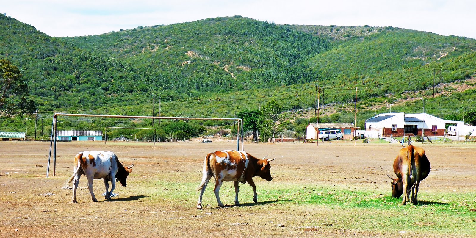
Cows grazing on the sports field, Caritas Primary school, Uitenhage, Eastern Cape
|
|
|
'Forties scenery' - Uitenhage
|
Booysens Park
 |
| Fishing community - near Port Elizabeth |
 |
| Colorful home - fishing community, near Port Elizabeth |
Bluelilliesbush
 |
| Bluelilliesbush, Eastern Cape |
 |
| Bluelilliesbush, Eastern Cape |
Graaff-Reinet
 |
| The rainbow nation - near Graaff-Reinet |
About Graaff-Reinet
Graaff-Reinet is a town in the Eastern Cape Province of South Africa. It is the fourth oldest town in South Africa, after Cape Town, Stellenbosch, and Swellendam.
The town was founded by the VOC (Dutch East India Company) in 1786, being named after the then governor of Cape Colony, Cornelis Jacob van de Graaff, and his wife, whose maiden name was "Reinet" (Wikipedia).
 |
| Monument - The Dutch Reformed Church |
 |
| Graaff-Reinet architecture |
 |
| Graaff-Reinet architecture |
 |
| Street scenery - Graaff-Reinet |
Somerset East
 |
| Somerset East - Eastern Cape |
Cookhouse
 |
| African hair salon - Cookhouse, Eastern Cape |
 |
| Rural house - Cookhouse, Eastern Cape |
Klipplaat
About Klipplaat
Klipplaat is a town in the Eastern Cape province of South Africa. It is a 185 km north-west of Port Elizabeth.
It is named after the large slabs of rock (in Afrikaans Klip or rock and plaat or sheet) on the surface (Wikipedia).
 |
| Klipplaat, Eastern Cape |
 |
| Broken school window - Klipplaat, Eastern Cape |
 |
| Playground - Klipplaat, Eastern Cape |
About Jansenville
Jansenville is a town in South Africa’s Eastern Cape Province. It is about 87 km south of Graaff-Reinet on the Sundays River.
It was laid out on the farm Vergenoegd in 1854, and proclaimed in 1855 and later became a municipality in 1881.
It was named after General Jan Willem Janssens (1762-1838), the last Batavian Governor of the Cape (Wikipedia).
 |
| Jansenville, Eastern Cape |
 |
| Jansenville, Eastern Cape |
 |
| Church - Jansenville |
 |
| Monument to Andries Pretorius |
Cradock
About Cradock
Cradock, a town in the Eastern Cape Province of South Africa, is located in the upper valley of the Great Fish River, about 250 kilometers north-east of Port Elizabeth (Wikipedia).
 |
| Cradock - Eastern Cape |
 |
| Dining room of the Victoria Manor hotel - Cradock |
 |
| Victoria Manor hotel - Cradock |
 |
| Cradock street scene - taken from the Victoria Manor hotel |
Tarkastad
About Tarkastad
Tarkastad is a small Karoo town in the Eastern Cape province of South Africa. It is located on a plain to the north of the Winterberg mountain range.
The name Tarkastad comes from the Khoi-Khoi word Traka (meaning women) and the Afrikaans word stad (meaning city). It was established in 1862 as a church center and became a municipality in 1864 (Wkipedia).
 |
| Bakery - Tarkastad |
 |
| Sheep galore - near Tarkastad |
Grahamstown
About Grahamstown
Grahamstown is a city in the Eastern Cape province of South Africa of about 70,000 people. It is about 110 kilometres north-east of Port Elizabeth.
It hosts Rhodes University, the Eastern Cape Division of the High Court, and 6 South African Infantry Battalion.
 |
| Grahamstown - Eastern Cape |
 |
| Grahamstown - Eastern Cape |
Port Alfred
About Port Alfred
Port Alfred is a small town in the Eastern Cape province of South Africa. It has a population of just under 26,000 and is situated on the eastern seaboard of the country at the mouth of the Kowie River, almost exactly halfway between the larger cities of Port Elizabeth and East London.
It was established in the early 1820’s by British settlers who were moved into the area by Lord Charles Somerset as a buffer between the Cape Colony and the Xhosa people.
Originally it was two separate towns (settlers arriving on the west bank in 1820 named their settlement Port Kowie, and those arriving on the east bank named theirs Port Frances.
When Queen Victoria’s son Prince Alfred visited, the place in 1860, the name was changed (Wikipedia).
 |
| Port Alfred marina - Eastern Cape |
 |
| Port Alfred marina - Eastern Cape |
 |
| Port Alfred marina - Eastern Cape |
 |
| Marina - photo was taken from the Nico Malan bridge, in Port Alfred |
 |
| Nico Malan bridge at night - Port Alfred |
 |
| The scenery on the road between Grahamstown and King Williams Town, Eastern Cape |
Fort Beaufort
About Fort Beaufort
Fort Beaufort is a town in Eastern Cape Province and has a population of about 26 000 (2011). The town was established in 1837 and became a municipality in 1883.
The town lies at the confluence of the Kat River and Brak River between the Keiskamma and Great Fish Rivers.
It serves as a mini-dormitory for academic staff and students of Fort Hare University, based in the nearby town of Alice, and is also close to sulphur springs (Wikipedia).
 |
| Fort Beaufort, Eastern Cape |
 |
| Fort Beaufort, Eastern Cape |
 |
| Near Alice - Eastern Cape |
Near King Williams Town
 |
| Nature scenery, near King Williams Town, Eastern Cape |
 |
| Nature scenery, near King Williams Town, Eastern Cape |
 |
| Nature scenery, near King Williams Town, Eastern Cape |
Toise
 |
| Toise, near Stutterheim |
 |
| Toise, near Stutterheim |
 |
| Toise, near Stutterheim |
 |
| Toise, near Stutterheim |


No comments:
Post a Comment